Two wildfires, caused by lightning strikes, have been located in remote areas of the Alpine Ranger District within the Apache-Sitgreaves National Forests, the Forest Service reports. These fires are being called the Fish Creek Fire and the KP Fire and currently pose no threat to communities or infrastructure, although nearby recreation area may become affected.
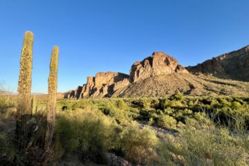
The Fish Creek Fire
The Fish Creek fire, which was detected on October 26, 2023, covers an area of 105 acres. It is situated 32 miles southwest of Alpine, to the north of Hoodoo Knoll, to the south of the Black River, east of Forest Road 25, and west of the Fish Creek drainage. The vegetation in this vicinity consists of a mix of coniferous trees, ponderosa pines, grass, oak, and locust, with a notable presence of heavy dead and downed fuel. Smoke is observable from Forest Road 25, 24, and the 25B, and it is expected that drift smoke will settle into the Black River drainage, particularly during the overnight hours.
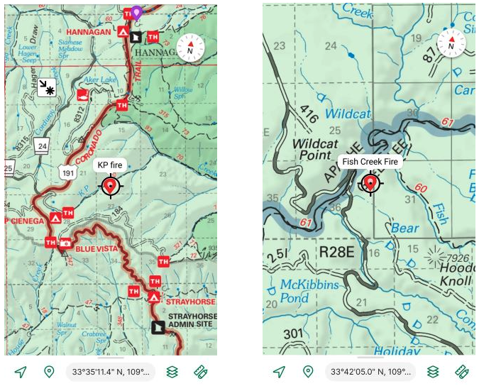
The KP Fire
The KP Fire was discovered on October 21, 2023, and it covers an area of 25 acres. This wildfire is situated 33 miles southwest of Alpine, to the south of KP Creek, to the north of Forest Road 184, east of Highway 191, and west of Sawed Off Mountain. The predominant vegetation in this area comprises mixed coniferous trees, aspen, locust, and grass, with most of the smoke visibility being along Forest Road 184.
Alpine Ranger District assessing and planning
Fire management teams are currently assessing factors such as the potential for long-term fire spread, the historical fire activity in the region, seasonal weather patterns, resource availability, and other relevant variables as they formulate a plan to manage the Fish Creek and KP Fires. Continuous monitoring is in place to evaluate any impact on values at risk, and a point-protection strategy will be implemented if these values are endangered. Presently, with the prevailing fall weather conditions, both fires are spreading at a slow to moderate pace, primarily consuming forest debris. There are no evacuations or closures advised currently.
It’s important to note that the communities of Alpine and Nutrioso may experience smoke-related issues, and affected residents can access air quality information at AirNow.gov.
Recreation areas that could become affected
As of 8pm November 2, no roads, trails, or campgrounds have been closed as a result of these fires but smoke, threat of wind change and spreading wildfire, or fire personnel on-site could affect access to these popular areas nearby:
- KP Cienega Campground
- Bluepeak Trailhead
- Strayhorse Campground
- North Fork/KP Rim Trailhead
- Forest Road 25 / Black River Trail Parking Area


0 Comments